
Introducing the Climate Smart Map: a data-driven resource for climate resilience in the Caribbean.
Climate change is a present-day reality for the Caribbean. Despite the fact that the Caribbean nations contribute only a tiny fraction of global greenhouse gas emissions, their vulnerability to climate risks is disproportionately high.
What’s more, the Caribbean’s economy relies on weather-sensitive industries such as tourism and agriculture rendering it particularly vulnerable to extreme weather events, putting livelihoods at risk. Meanwhile, the region’s ability to manage these growing threats is constrained by limited resources and capacity.
Put the Caribbean back on the map: A data scarcity issue.
According to Kiesha Farnum, Director of Public Sector Projects at the Caribbean Climate-Smart Accelerator (CCSA): “Even Google sometimes does not know what is happening in the Caribbean […] The amount of data that is available for some of these overseas territories is very little.”
At Vizzuality, we are driven by the belief that data, when presented in an accessible way, has the power to inspire change. That is why we’re proud to have partnered with CCSA to bring this vision to life with the Climate Smart Map, an interactive platform designed to empower the Caribbean in its efforts towards climate resilience and sustainability. Unveiled for the first time during COP28 in Dubai, the Climate Smart Map marks a milestone in the region’s quest to become the world’s first Climate-Smart Zone.
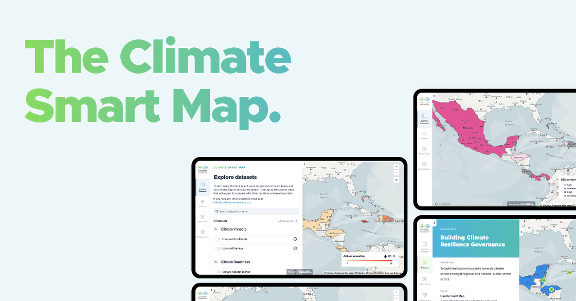
CCSA — an NGO dedicated to establishing a Climate-Smart Zone across the Caribbean region — brought Vizzuality on board to play a key role in developing this groundbreaking tool. Designed with the end-user in mind, the Climate Smart Map makes complex climate data easy to navigate, enabling everyone from policymakers to investors and the general public to understand the region’s climate risks and opportunities at a glance.
The Climate Smart Map: A vision for impact.
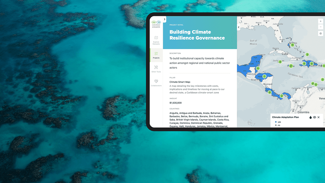
CCSA’s goal with the Climate Smart Map was simple: to ensure that decision-makers across the Caribbean have access to timely, accurate, and actionable climate data. By visualizing risks and vulnerabilities alongside adaptation efforts and governance readiness, the platform provides a clear path forward for climate action.
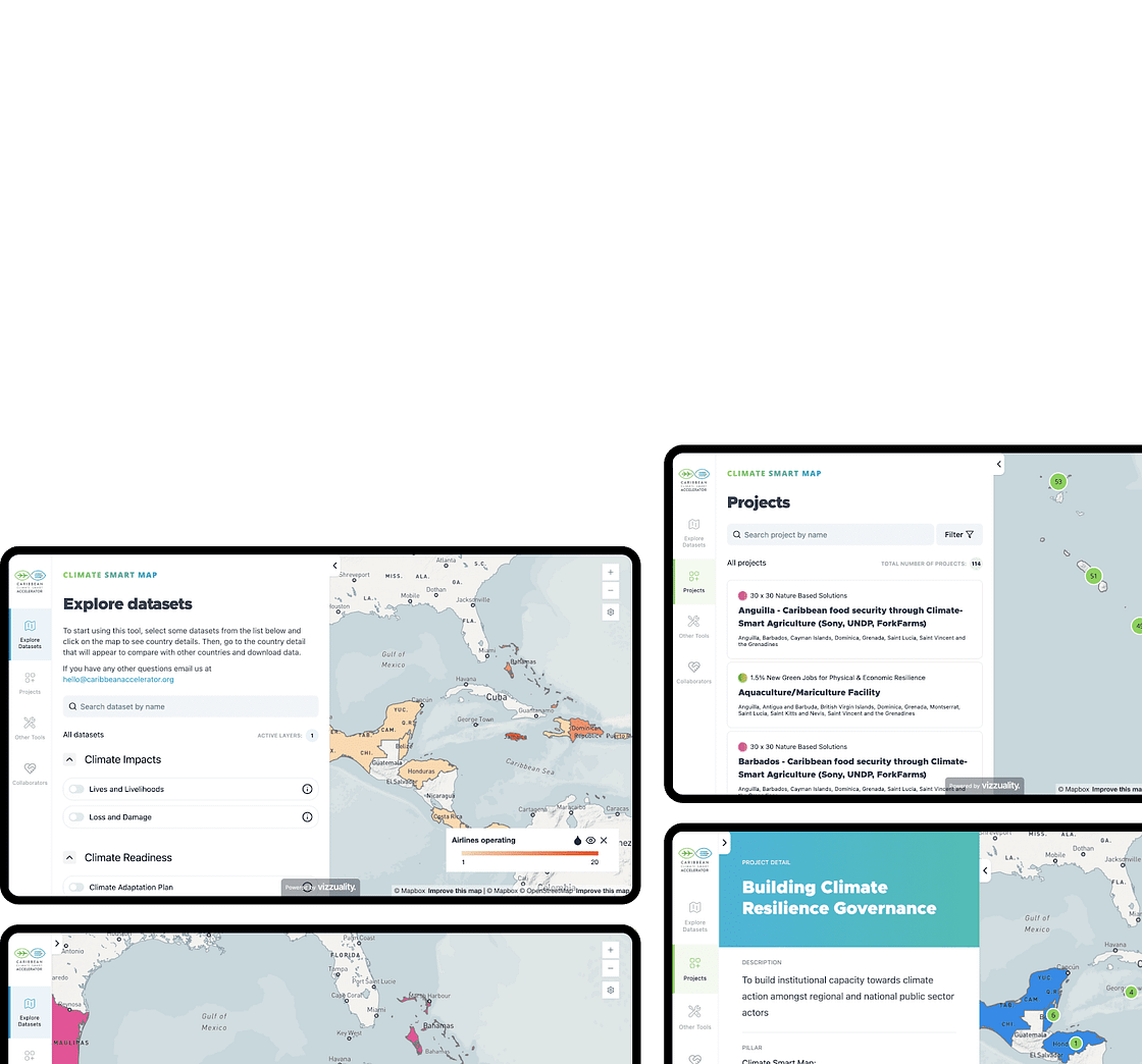
We’ve worked hard to ensure that the map is not just a tool for experts, but one that is intuitive and engaging for everyone who needs it — whether it’s a government official planning for the future, an investor seeking high-impact opportunities, or a student researching climate solutions. The interactive interface brings the data to life, making it easy for users to explore critical information on a country-by-country basis or across the entire region.
The power of data in climate action.
The Climate Smart Map showcases the power of data in addressing the Caribbean’s climate challenges. Throughout the development of the map, the CCSA and Vizzuality teams have been attentive to keeping this reality at the forefront.
The map is designed to empower the Caribbean to navigate the complex terrain of climate adaptation and represent the region’s progress and the richness of its efforts towards climate resilience.
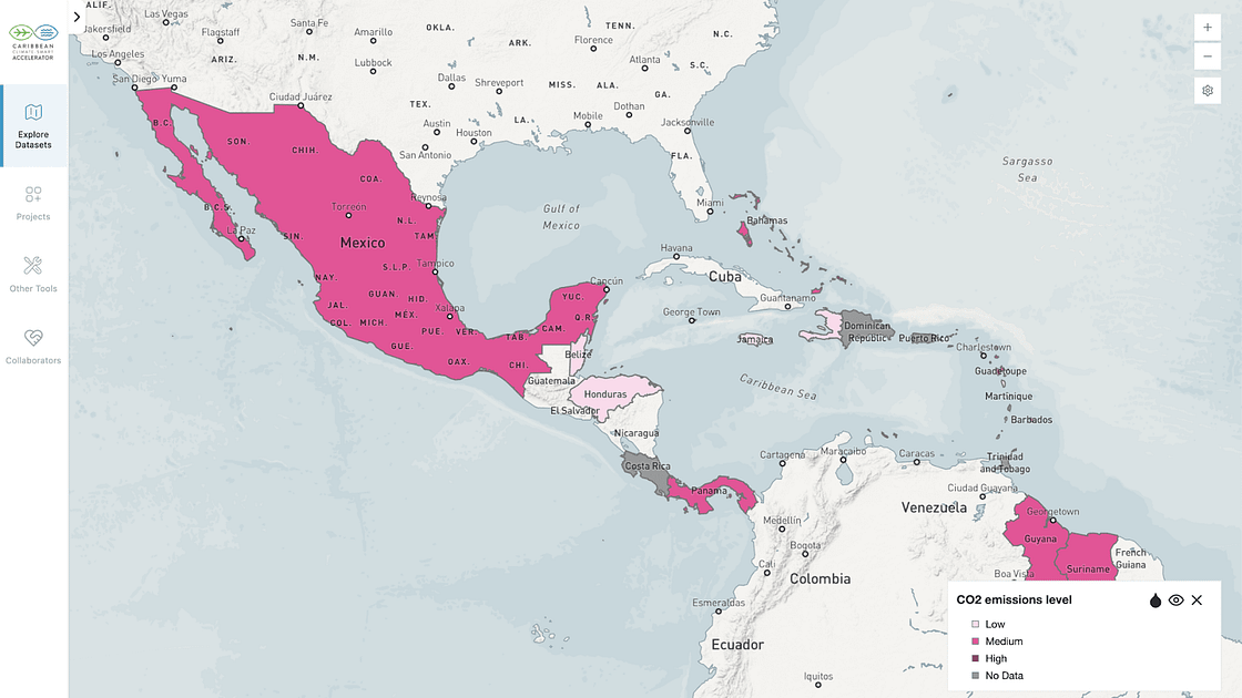
This tool integrates multiple layers of information, from climate vulnerability and readiness to governance structures and adaptation projects. It allows users to pinpoint where resources and efforts are needed most, highlighting gaps and opportunities across 26 nations. It’s about taking a vast, interconnected problem like climate change and breaking it down into actionable steps.
A catalyst for collaboration and innovation.
By making data accessible, we are helping to bridge the gap between research and action, enabling stakeholders across sectors to come together and make informed, impactful decisions. The platform plays a crucial role in supporting the CCSA’s broader goals, such as transitioning to 90% renewable energy by 2035, protecting 30% of land and water by 2030, and creating new green job opportunities across the region.
Vizzuality will continue to work closely with the CCSA to meet the growing demands of climate action in the Caribbean. For more information on our role, head out to the project’s page on our website.
Working towards collective climate resilience.
The launch of the Climate Smart Map at COP28 last year represented a major step forward in the Caribbean’s journey toward climate resilience.
CCSA’s proposal stemmed from a common issue: both donors and project holders struggled to find a centralized source of regional climate initiatives. For instance, in August 2023, CCSA’s call for projects in Jamaica yielded five hydroponic proposals. This highlighted the need for a platform that fostered collaboration instead of competition, enabling projects to attract targeted funding through regional synergy.
The Climate Smart Map was therefore developed to provide donors and project holders with a clear view of ongoing efforts and to build communities of practice.
“The Climate Smart Map is a center of excellence for the region. We have so many young Caribbean people doing amazing things, and I want the world to know that we are the architects of our own survival,” said Kiesha Farnum during the Climate Smart Map Launch.
It is an honor for Vizzuality to be part of this transformative initiative. As the map gains traction, we’re excited to see how it will drive strategic climate investments, guide policymaking, and inspire community-focused innovation across the region.
Explore the Climate Smart Map here: https://map.caribbeanaccelerator.org/
.png)


